Category: panorama photography

New Zealand and French Polynesia – January 2013

Introduction

I do not typically use this blog to discuss personal events except as a framework to discuss the photographic techniques I used to create the images I discuss about a particular photo trip. However, I will make an exception in this case and discuss my vacation to New Zealand and French Polynesia in January, 2013 with as much focus on photography as I can.

Here is a direct link to the New Zealand photo gallery.

New Zealand

I departed LAX on Saturday January 5 around 10 PM and landed at AKL on Monday January 7 at 8 AM or so. From there I waited a few hours and then boarded a flight to Queenstown on the South Island. The overnight flight and morning arrival coupled with my extra-cost super economy seat meant I was not jetlagged in any way. I carried my new camera, a Canon 6D, which is an “affordable” full frame sensor D-SLR with both WiFi and GPS built-in. I also brought my trusty 24-105 f4 IS lens and my 50 mm f1.4.

South Island

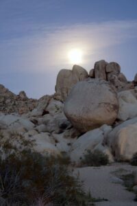
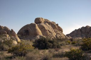
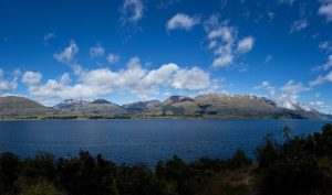
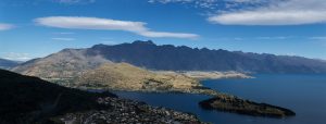
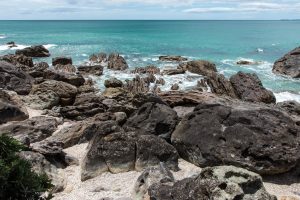
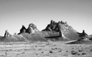
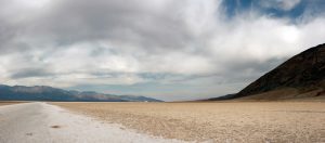
Queenstown is the center of the NZ action sports/activities universe. In winter it is a ski resort destination, in the summer it is the bungee jumping, jet boating and zip-lining capital. It is also in the middle of some utterly spectacular scenary – the Remarkables mountains and Lake Wakatipu. Nearby is Lake Wanaka and Mt Aspiring with the Rob Roy glacier – very alpine.

Mountains and clouds above Lake Wakitapu

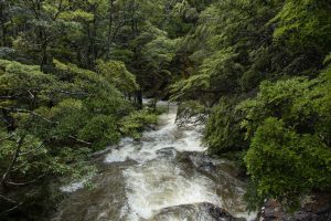
Queenstown is at roughly the southern latitude as Portland, OR is north – 45.5 degrees – and has the same weather. This meant that the weather was cool and cloudy with rain and snow at the higher elevations for part of the first week. It was nice weather for hiking and roadtripping, but not for photography. The only exception was some forest images I took while hiking a trail (Kiwis call them “tracks”) to Mt Creighton near Lake Wakatipu. Forest light filtered by rain clouds is less intense and allows for interesting light and dark interplay due to the low contrast environment.

Rain-swollen stream near Mt Creighton, New Zealand

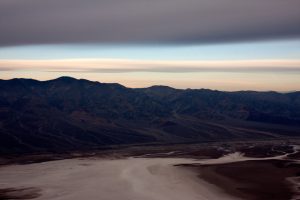
My first few days were in the Queenstown area, driving along Lake Wakatipu to the western end at Glenorchy, taking a cable car up a mountain to get an alpine overview of the entire town, the lake and the surrounding mountains and then later when the weather cleared for a few days driving to Lake Wanaka and Mt Aspiring National Park. I also went out Fiordland National Park and Lake Manapouri.

The Remarkables mountain range above Queenstown, New Zealand

I had planned a cruise on Milford Sound but the weather did not cooperate and that activity had to be cancelled.

Ultimately the South Island weather cleared up and presented many opportunities to explore, be awed by and photograph some of the most incredibly beautiful scenery I’ve ever experienced.

North Island

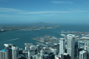
After a week of fun on the South Island I flew from Queenstown to Auckland and then went by car to Cambridge, a town near Hamilton. Cambridge is near a town called Te Awamutu, the home town of a favorite musician of mine, Neil Finn. The main library in that town includes a small museum, and in the museum is a “shrine” to the Finn brothers, Neil and Tim. I went there for an hour or so one day. I also visited a very pretty seaside beach town called Taurunga, whose main geological feature besides the coastline is a small dormant volcano cone called Mt Maunganui. The North Island is still volcanically active; not only is Auckland surrounded by dormant volcanoes but there is a small thermal public bath at the base of Mt Maunganui.

Eroded rocks – Mt Maunganui, Tauranga, New Zealand

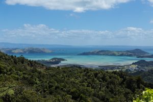
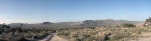
I learned to drive one day and then took a borrowed car on my own out to a region called The Coromandels, which is a lightly populated peninsula of vacation beach towns and beautiful rain forest. A few days out there was not enough time, but I managed to drive the entire paved highway (highway 25). The rest of the peninsula is reachable only by gravel road, something I was not willing to drive on with the car. If you click on the linked map, you’ll see that this sparsely populated, very wild and natural area is only about 20 or 30 miles across the bay from Auckland. Highlights of this part of the trip were definitely Cook’s Beach and Hot Water Beach and Mercury Bay.

Looking west from the top of Hwy 25 in the Coromandels.

I wrapped up my second week in New Zealand by seeing Elvis Costello and the Imposters live in Auckland, staying in the city through the weekend then flying to Papeete, Tahiti, French Polynesia that Monday morning.

View of the harbor from Auckland Sky Tower

French Polynesia

Here is a direct link to the French Polynesia photo gallery.

Tahiti

I flew from Auckland, New Zealand to Papeete, Tahiti, French Polynesia. I departed Monday morning 10 AM and arrived in Papeete (Faa’a International Airport) at about 4 PM Sunday afternoon. Papeete is the capital city and is the “Honolulu” of French Polynesia. Tahiti itself is the largest island. I stayed overnight on Tahiti and in the morning I took a puddle jumper aircraft from Faa’a to Moorea’s airstrip, a 12 minute flight.
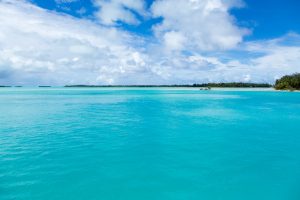
Moorea

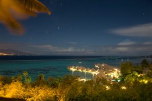
Moorea is 12 million years older than neighboring Tahiti and the volcanic crater erosion and barrier reef demonstrate its age. I was staying on Cook’s Bay. I was visiting French Polynesia at the lowest of the low season; there were a grand total of 6 people in my hotel. It meant I had the place to myself, basically and no one seemed to really care. The weather was not very good; it rained in a monsoon the night of my arrival and it was gray and drizzly the first full day on Moorea, but eventually the clouds dissipated and the sun came out. I was able to get a lot of beautiful images by renting a car and driving around the island and taking a boat ride. I even did some long exposure timelapse images one night. I was on Moorea 3 nights and had a good time.

Under a Tahitian Moon – timelapse of the Moorea reef

Bora Bora

I then flew to Bora Bora, which is the classic South Pacific tropical island but was a bust for me. The weather did not cooperate at all, the island was under a hurricane warning (it was 500 km away but it meant the hotel reduced some of their services) and it wasn’t as much fun as Moorea. Eventually I got sick, probably from drinking the water. I was there two nights and flew back to Papeete and then home the same day.

The Bora Bora lagoon from the airport dock

Death Valley November 2012 Photo Trip

Earlier this month I again went out to what has become a favorite location for photography of mine – Death Valley National Park. The goal was to once again work on low-light, night and long exposure techniques for the most part at night and do fun exploring and typical dawn, dusk and HDR work during the day.

The technique I was most focused on this time was exposure stacking, which is a Photoshop technique where a series of short-ish long exposures of the night sky are layered together to achieve the same visual effect as a single long exposure. The image below is the most successful example I have from the trip; a mesquite bush on a sand dune with a series of 60 20-second-long exposures to give a total exposure effect of 20 minutes. The mesquite bush was lit for a few minutes with a hand-held flashlight using a painting-with-light technique.

A Moonlit Scene Looking West to the Panamint Range from Death Valley National Park’s Harmony Borax Works site

The stacking technique is superior to the single long exposure technique for me now for several reasons. First, the sky stays black since the 20 seconds at f4.5 and ISO 100 exposure used in this case is not enough to lighten the sky. Second, sensor noise does not build to a detectable degree with a 20 or 30 second exposure. I believe my workhorse Canon 40D may be getting “old” because it seems that longer (multi-minute) exposures are much noisier now than they were even 2 years ago.

This next photo is a late afternoon 3-image HDR shot looking east across the valley at the Amargosa Range from 6400 ft (2000 m) high Aguereberry Point in the Funeral Range very near Telescope Peak. This was a 6 mile improved gravel road drive that my 2005 Camry was able to do, much to my surprise and delight. I arrived at the overlook about an hour or so before the sun dropped below the Sierras and Panamint Ranges and I was able to get a few panoramas and HDRs of the views.

Another site visited was Trona Pinnacles, which I visited on the drive out to the park. Trona Pinnacles is in the California Desert National Conservation Area and is an unusual set of tufa formations. They have been the site of many film and advertising shoots and are unusual looking. They were formed from between 10 000 and 100 000 years ago, when the area was a large Pleistocene Era lake.

A multiple image panorama of the Tronas Pinnacles

A three image HDR photo of the Tronas Pinnacles in Tronas, CA


I have an album of photos from this Death Valley trip in my photo gallery immediately next to the Anza Borrego night sky photo.


Death Valley February 2012 Photography Trip

Earlier this month I spent a long weekend in Death Valley National Park on a photo safari. Death Valley is a favorite destination for me because it is typically fair weathered and clear skied during the day and night. I had timed my visit to correspond with a waning full moon with the idea that I would do a lot of long exposure work using the light of the moon to illuminate the desert floor and mountains.

Unfortunately the weather was not cooperative; beautiful cloud-filled skies during the day and complete overcast at night (!) meant that my primary goal was not met. Instead I did a lot of panorama and HDR photography during the day and experimented with flash and “painting with light” techniques at night.

This is the overlook from Dante’s View of the Badwater Basin area – it’s looking due west. The moon had risen just a few minutes prior to opening the shutter. The image is 1408 seconds, roughly 25 minutes. The cloud cover has already moved in, blocking the stars and the sky to the west. But it is worth noting that even under these conditions there is sufficient light to expose the floor of the salt pan at Badwater and to illuminate the sky. Star trails are faint but visible in larger versions of this image, too. So, this is a failed image but a success at proof-of-concept.

This is a 3-image +/- 1 f-stop HDR image of a mesquite tree on a sand dune near Stovepipe Wells. I deliberately went for a more surreal look to the HDRs I took here.

Rhyolite, Nevada’s Cook Bank Building in silhouette

The Cook Bank Building at the ghost town of Rhyolite, Nevada. 3 image +/- 1 f-stop HDR image.

A 10 image panorama of Death Valley’s Badwater Basin area.

An old pulley on mining equipment at Death Valley California’s Warm Springs Campground

Some Depression-era mining equipment at Warm Springs Camp. Accessible by Jeep, Warm Springs is a former mining camp nestled in a small valley in the middle of the Funeral Mountains on the western side of Death Valley. The spring there is constantly flowing and was used as a source to fill a large swimming pool (visible in the Google Maps link) at the camp.


I have an album of photos from this Death Valley trip in my photo gallery immediately next to the U2 Joshua Tree photo.


Joshua Tree National Park Full Moon Photography

Lunar Apogee

This weekend was a lunar perigee full moon. These don’t happen all that much together; perigee is the moon’s closest point to Earth in its orbit so the net result is an ever so slightly larger and therefore brighter moon. I decided to take advantage of this situation by driving to Joshua Tree National Park, a roughly 3 hour trek. I left the house around 12:30 PM and arrived at the Visitor’s Center at the northern edge of the park at 3:00 PM. A quick discussion with a ranger, a purchased entrance fee and off I went into the park. I drove on Geology Tour Rd and Queen Valley Rd (both unimproved) before deciding on hanging out along a stretch of Geology Tour Rd. The ranger assured me that area would very dark and pretty much devoid of people.

I stopped at the very southern corner of Geology Tour Rd and shot this panorama looking north of Pleasant Valley.

Setting Up and Weather

I found a good turn-off next to the road and set up. The moon rose above the rock formations and I took this image.

The full moon is behind a cloud. This was an ominous beginning; the clouds were coming in from the coast in front of the rain storm that hit us the next day. The clouds cut down the light available and made exposure estimation that much harder.

This was a multiple-minute exposure of a granite rock outcropping just off the road.

Eventually the clouds became so heavy I had to abandon the activity; the light was less than half what it was at the beginning of the evening.

Lessons learned:

1. Bring extra batteries. I went through a double battery pack in 3 hours of shooting. The long exposures really drain the batteries.
2. Next time I’ll get a hotel room out there and work all night instead of feeling like I had to get done by a certain time so I could safely drive home.
3. Give more time for location scouting.
4. Improve my autofocus management technique.


The History of Rome: Papal Basilica Santa Maria Maggiore

Another article in an occasional series on the history of Rome.

Founding and Construction

, Santa Maria Maggiore (St Mary Major) built in the 5th century AD. One of the four Papal basilicas in Rome. Its ceiling is covered with gold brought back from the New World.

Santa Maria Maggiore (St Mary Major) is one of 4 papal basilicas in Rome. The others are:

San Giovanni in Laterano (St John in the Lateran)

San Paolo Fuori le Mura (St Paul Outside the Wall)

San Pietro in Vaticano (St Peter in the Vatican)

It is one of the 4 churches the Pope holds Mass in and each church’s plot of land is a little piece of the Vatican.

Construction

Built in 8 years from 432 to 440, Santa Maria Maggiore sits on the summit of the Esquiline Hill, on a place that legend says was the location of an August snowstorm in 358. A childless couple was visited by the Virgin during their sleep and were told to build a church on the spot where snow fell the next morning. This led to the church first being called Santa Maria della Neve (St Mary of the Snow). Every year in August the legend is re-enacted by Rome Catholics who drop white flower petals from the dome during the feast day festival.

Over the centuries the church was expanded and remodeled but its interior remains true to its original construction; its layout looks very much like a 1st century Roman basilica, which for them was not a church but in fact a shopping mall/civic center building. It has a long tall nave, two aisles (one on either side) and a semi-hemispherical dome at the far end. Its overall length is 92 m, its overall width is 80 m and the nave is 30 m wide. It’s 75 m high. The ceiling is said to be gilded with gold brought back from the New World. The columns inside are recycled from an older Roman temple.

Mosaics and Art

Interior apse mosaic in the basilica Santa Maria Maggiore in Rome, Italy. Mosiac depicts Mary and Christ and dates from the 9th century AD.

Apse

The mosaics in this church are nothing less than spectacular and should be the main focus of a visit. The dominant work of art in Santa Maria Maggiore is doubtlessly the apse mosaic. Created in 1295, it features Jesus and Mary surrounded by representations of the Tree of Life, the Apostles and other liturgical symbols. A truly stunning work, it set the standard for representations of Mary in Catholic art for centuries.

Interior of Rome, Italy’s Santa Maria Maggiore basilica with the baldachino and mosaics.

Triumphal Arch

The Triumphal Arch is also similarly beautiful. It illustrates scenes from Christ’s life and its theme is The Infant Savior. Because these works are older than the Council of Nicea, the Triumphal Arch in this church includes a scene that didn’t make the cut in the official New Testament (Christ as a baby is brought to a temple but His holiness causes the temple statues to crack and fall from their pedestals). Thus Santa Maria Maggiore’s Triumphal Arch mosaic is the only example of Christian art that contains a scene of Christ’s life not in the Bible.

Nave

Standing in the back of the nave you can see directly above the columns and architraves and underneath each window mosaics of Old Testament history. Research has dated them to circa 432-440, in the pontificate of Pope Sixtus III. Since the natural light in the church is very low, the best way to see them is to be in the church just prior to a service. They are then lit with artificial light and they absolutely glow! Some of them were heavily restored with paint during the Middle Ages, and some were reconstructed in 1593 and later.

Of the original 42 panels, 27 have survived to today. Fifteen have been lost through the ages; some of those when the Pauline and Sistine Chapels were built (you can see the archways at the end of the nave built for their entrances).

Additions

The Sforza Chapel is interesting because Michaelangelo designed it in 1564 (and completed in 1573 by Giacomo della Porta). Because so many of his works are now “off limits” to the general public it is nice to be able to not only walk up to one of his creations but actually walk into one. The original entrance to this chapel was a large arch, but it was demolished in the mid-1700’s.

This church also has a Sistine Chapel, but this Sistine Chapel is nothing like the famous one in the Vatican. Any chapel built by a Pope named Sixtus (there were 5 of them) is named “Sistine.” Laid out in a Greek Cross plan with a magnificent dome capping it, the Sistine Chapel known officially as Blessed Sacrament Chapel is a truly outstanding creation. Domenico Fontana designed it and work began in 1585. It is the burial place of Pope Sixtus V.